Dark diversity

I find it of paramount importance that students learn how to communicate their research. Summarizing their ideas and findings for a broad audience challenges them to keep the ‘why’ in mind for their research, and reminds them they are part of a bigger effort to solve the remaining mysteries of our world. In this mini series, all master students of this academic year present their work in around 300 words. Number five: Lore Hostens.

Dark diversity – what drives the absence of species in a Scandinavian tundra?

Several factors can cause the local diversity to decrease. The term “dark diversity” covers the plant species that are missing from an area but could be there based on their climatic niche. In this thesis, the dark diversity of the Scandinavian tundra will be studied. Based on extensive vegetation surveys in the northern part of the Scandes mountain range, over the years a good knowledge of the fine-scaled distribution (presence and absence) of plant species has been obtained. To find which species are part of the dark diversity, Species Distribution Models will be made for all common species in the flora, linking the presence/absence data of species distributions to high-resolution climate variables. This way, we can predict at the plot-level which species could be expected there based on their climatic niche.

Fig. 1: scheme of the research

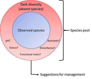
Next, we will dig into the reason why these species are absent in that specific plot. We will distinguish between natural factors, such as soil characteristics (pH, available nutrients) and the functional traits of the species under study, and factors related to anthropogenic disturbances. We’ll look at the distance from linear disturbances to see whether it impacts the species composition in the plots. Some species can be very vulnerable to anthropogenic disturbances whereas others are not. Perhaps there is a link with the status of the absent species, meaning whether they naturally occur in the region (native species) or have been introduced (alien species). It could be that more native species are missing from highly disturbed plots and more alien from undisturbed plots.

Fig. 2: fieldwork

Results from these analyses will be connected with conservation. What drives the absence of species most? Is it the anthropogenic factors like linear distance from roads? Or is it natural factors such as soil characteristics? Or a combination? With this, a conservation management plan can be suggested. Perhaps reducing anthropogenic disturbance impacts the local flora positively. Hopefully, this research will provide a picture of the dark diversity of the Scandinavian tundra and if the missing species can inform management decisions.

Posted in Sweden | Tagged , , , , , , , | Leave a comment

Climate-resilient cities

I find it of paramount importance that students learn how to communicate their research. Summarizing their ideas and findings for a broad audience challenges them to keep the ‘why’ in mind for their research, and reminds them they are part of a bigger effort to solve the remaining mysteries of our world. In this mini-series, all master students of this academic year present their work in around 300 words. Number four: Kobe Tilley.

Around one quarter of the Flemish urban area consists of private gardens. Clearly, they are a potential significant spatial factor regarding urban climate resilience. However, there is no such thing as ‘the urban garden’, every garden looks different.

When we look at the most challenging consequences of climate change for urban areas, we see an increasing Urban Heat Island (UHI) as one of the most complex ones. The UHI arises when urban structures such as asphalt and concrete absorb heat during the day and release it again during the night. Consequently, temperatures will be warmer – and remain so for longer during the night, with significant effects on the health and well-being of city-dwellers.

Flanders, a sprawled region

With this in mind, we return to the urban gardens. As they are occupying one fourth of the urban area, they might be a means to adapt cities to this UHI. As they are often islands of green in a sea of grey, they absorb less heat during the day, and thus release less of this heat at night. But what role do different types of urban gardens and their spatial configuration play in adapting to the UHI? What is the effect of gardens’ sizes on the UHI? And what is the difference between many small gardens versus a few big garden complexes? Finally: when we know these results, how can we act as urban planners to create a more climate resilient city? These are the questions I will be looking into with the help of temperature data, collected by a network of over 4000 miniature weather stations placed in Flemish gardens from the ‘CurieuzeNeuzen in de Tuin’-project. By linking these temperatures to measures of garden configurations and data about the garden design, I want to find answers on how to use gardens and urban planning for creating a climate resilient, urban environment. Since our planet will keep warming for a while and weather extremes will hit hardest in cities, climate-conscious urban planning will become increasingly important.

Figure 1 – Zoom on an area in Flanders with urban, suburban and rural structures close to each other. Even in this small selection, we can distinguish differences in garden configurations. Denser within the urban area, rather more sprawled in the rural parts. The suburban area is the ‘in between’, which is dense but also more sprawled. To represent all landscape types, the miniature weather stations (CNidT-locations) are found all over Flanders, in urban areas, on the countryside, and in between. (Sources: RURA Vlaanderen, Tuinenkaart KU Leuven, CNidT-locations; map: Kobe Tilley, 2021).
Posted in Belgium | Tagged , , , , , , | 1 Comment

Bumblebees on the mountain

I find it of paramount importance that students learn how to communicate their research. Summarizing their ideas and findings for a broad audience challenges them to keep the ‘why’ in mind for their research, and reminds them they are part of a bigger effort to solve the remaining mysteries of our world. In this mini series, all master students of this academic year present their work in around 300 words. Third post: Renée Lejeune.

In this project, we try to link distribution limits of the plant species present on the ‘Nuolja’ mountain in the Scandinavian tundra with pollinator presence. Plant surveys were done along a specific transect on Nuolja to determine all the present species and their abundance per location. The transect consist of 13 locations along the whole elevation gradient. The same 13 locations were also used for the bumblebee surveys. Per location, bumblebees were surveyed in one big plot, and vegetation was surveyed in 4 smaller plots equally distributed in the different quadrants (A, B, C & D)(see figures below).

During bumblebee surveys all visited plant species were noted down. The research will only focus on the plant species visited by bumblebees. For these selected plant species the elevation limit can be determined and since plant surveys were done in previous years as well, a possible shift in elevation limit can be seen. For the bumblebees similar elevation limits can be determined and also a possible shift in these limits. Depending on how well both elevation limits match with each other, we can calculate how much variation in the plant distribution can be explained by the presence of pollinators.

We hypothesize several possibilities: for example, when bumblebees occur all across the elevational gradient on different plant species, we could expect a smaller or even no effect on upward plant movement. A bigger effect might on the other hand be seen when the bumblebees themselves are limited to certain heights and plant species moving up would thus have to wait for their pollinators. Disentangling these relationships is important to understand the role of pollinators as facilitators – or hindrances – for plant distribution changes. This can also give a better idea of how climate change directly and indirectly, through pollinators, affects plant distribution.

Posted in Sweden | Tagged , , , , , , , , | Leave a comment

Wet nature as airco for the city

I find it of paramount importance that students learn how to communicate their research. Summarizing their ideas and findings for a broad audience challenges them to keep the ‘why’ in mind for their research, and reminds them they are part of a bigger effort to solve the remaining mysteries of our world. In this mini series, all master students of this academic year present their work in around 300 words. Second: Amber Pirée!

Most of us in Belgium will remember the past summer’s weather as outright miserable. The debilitating heatwaves and problematic water shortages of the summers of 2018, 2019, and 2020 may have already started slipping our minds. Yet such heatwaves and droughts, interspersed with periods of extreme rainfall and flooding, are predicted to become the new normal. During the sweltering days and nights in a heatwave period, we often seek coolness from air conditioning, take more refreshing showers or install swimming pools for children to play in. Our gardens and arable lands are being watered more often to keep plants from withering. As important as refreshing is on such days for our health, it is accompanied by high economic and climate costs.

Another well-known way to escape some of those high temperatures in the city, is seeking shelter in nature. We experience that urban areas get warmer than rural areas, because cities, with their paved surfaces and dark materials such as asphalt and concrete, retain heat longer. In Belgium, 98% of us live in these urbanized areas, making it important to investigate how we can bring more of that countryside refreshment into the city. Therefore, almost 5 000 participants of the ‘CurieuzeNeuzen in de Tuin’ citizen science project placed small weather stations (affectionally called ‘lawn daggers’) in their gardens. Additionally, we installed a network of these sensors across nature reserves.

‘Lawn dagger’ @Bart.vdsm

This generates a unique dataset of microclimate data on soil temperature and soil moisture for the whole of Flanders. In this strand of the ‘CurieuzeNeuzen in de Tuin’ project, we ask ourselves: are these nature reserves cooler than urban gardens? And how far into the city does the influence of natures’ natural airco’s reach? More specifically, we will look at the influence of the amount of paved surfaces, forest or grassland, water elements, and agriculture on local temperatures. The ultimate goal? Quantifying the buffering impact of nature and green spaces on microclimate – and thus the quality of life for humans and nature – in a highly urbanized region.  

Temperatures in the city center of Antwerp during the night of June 15 were up to 9 °C higher than in the surroundings. Figure made by De Standaard.
Posted in Belgium | Tagged , , , , , , , , | 1 Comment

100 years of vegetation data

I find it of paramount importance that students learn how to communicate their research. Summarizing their ideas and findings for a broad audience challenges them to keep the ‘why’ in mind for their research, and reminds them they are part of a bigger effort to solve the remaining mysteries of our world. In this mini series, all master students of this academic year present their work in around 300 words. First up: Dymphna Wiegmans

Historical data over the past 100 years may reveal important climate and land-use change impacts on vegetation composition in the Scandinavian mountains.

With the looming presence of climate change, subarctic ecosystems are changing rapidly in vegetation composition. Plant species are either moving uphill or disappearing entirely, with dramatic repercussions for ecosystem health and stability.

Climate change is occurring twice as fast in subarctic regions than in most others, but this is not the only major disturbance, land-use change and tourism are two other common disturbances that may disrupt native vegetation and introduce new species to a region. Together, these pressures could lead to a shift in biodiversity and ecosystem functioning.

Our research focusses on the Abisko region – a village in Northern Sweden that lies approximately 250 km above the Arctic circle. Due to low mean annual temperatures, arctic permafrost occurs here and the region accommodates a unique biodiversity, with a lot of rare plant species. However, climate change, land-use change, and tourist activity increasingly impact this region. For instance, intense human activity and warmer temperatures lead to the introduction of ruderal species that are exploiting the warmer climate and increased disturbance. Due to their ecological needs, ruderal species may increase in numbers over time and will contribute to changes to the subarctic ecosystems in Abisko.

The Rallarvägen trail around Abisko, setting of more-than–a-century-old vegetation survey

In 1903 and 1913 botanist Nils Sylvén made vegetation surveys along the Rallarvägen trail: a trail established for the building of the railroad from Kiruna to Narvik. He started in Abisko and surveyed all the way up to Riksgränsen, at the border with Norway (40 km). In the following decades, a few other surveys were done in the region, resulting in a wealth of historical vegetation data that has up till now never been left unexplored. After Sylvén’s first survey, the railroad was built in 1904, paralleling the Rallarvägen trail, with a couple of intersecting train stations and settlements. Since then, the trail itself became popular amongst hikers. In the summer of 2021, almost 120 years after Sylvén, we revisited and resurveyed the trail. Together with climate data from the Abisko Scientific Research Station (ANS), available since 1913, and with additional plant distribution data from other trails ranging from the Rallarvägen into the adjacent mountains, we intent to investigate how climate and/or land-use change influences the vegetation composition and their migrations uphill in the Abisko region.

Posted in Sweden | Tagged , , , , , , , | 1 Comment

ME&B conference

Preparations are now in full swing for the first ever international microclimate ecology conference, which we’ll host here in Antwerp from the 28th-31st March 2022. The Microclimate Ecology & Biogeography conference is a joint collaboration between the microclimate labs from the Universities of Antwerp, Ghent and Leuven and is supported by our SoilTemp network. Both abstract submission and registration are now open, and can be found on our website!

This conference will be held in Antwerp over 4 days and will be an in-person and online event. It will cover a wide range of microclimate-related topics, from arctic ecosystems to tropical ones and all species and ecosystems in between, as well as from a tiny scale to a global scale.

We got interviewed by Flora Passfield from the BES Forest Ecology section about the what’s and why’s of our conference, very much worth checking out the story here!

Posted in Belgium | Tagged , , , , , , | Leave a comment