
Let me tell you something important – which won’t be a surprise to regular followers of this blog: weather station data doesn’t do the trick for ecologists. It is just too different from the climate as experienced by most organisms, and relates to it in non-linear ways.
Yet, and that is the most important part, we made a huge step forward to solve that mismatch! We published the concept of our SoilTemp-database just now in Global Change Biology, introducing our ambitious plan to the scientific community and calling on all who want to listen to submit their microclimate data to our growing database (yes, that’s you as well! Do you have microclimate measurements? Then get in touch! More on our website).
And growing it does!
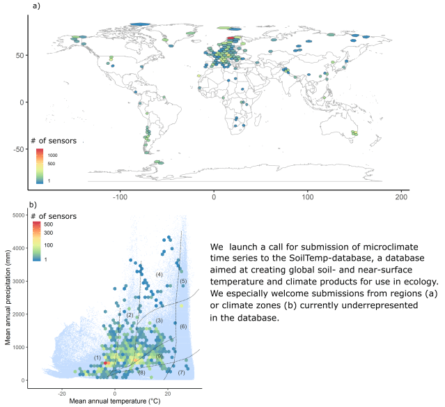
Overview figure of the database at the moment of paper acceptance (as it keeps growing!): a) shows the geographical spread of the 7538 (!) loggers from 51 (!!) countries we already have processed, while b) gives the spread in the worlds’ climatic space (the blue smear in the background indicates all types of combinations of temperature and precipitation that exist in the world, and we are covering quite a bunch of them).
The paper also explains why it is that this microclimate is so different from the macroclimate as interpolated from weather stations. In short, there is two things that together constitute that offset between micro- and macroclimate: horizontal and vertical features.
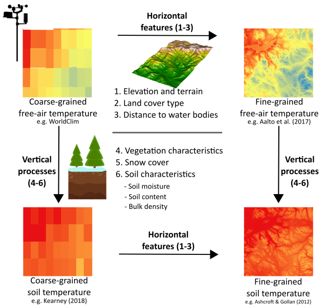
The difference between coarse-grained free-air temperature and fine-grained soil temperature is driven by horizontal andvertical features.
The horizontal features relate to the spatial resolution of the climatic data. They include features at a specific site (like effects of slope and aspect on local radiation balances, with south-facing slopes much warmer than their north-facing counterparts), and those where temperatures are also affected by neighboring locations (like topographic shading, cold-air drainage and atmospheric temperature inversions, which are landscape context dependent).

With horizontal features we capture the temperature differences between the left and right side of this picture, where local temperatures are driven by a difference in solar radiation input on a cold winter morning
The vertical features are what drives the difference between air and soil temperature and include the effects of vegetation characteristics (e.g. structure and cover), snow cover and soil characteristics (like moisture content, geological types, and soil texture). They cause an instantaneous temperature offset between air and soil temperatures, but also a buffering effect, i.e. the temporal variability in temperature changes is lower in the soil than in the air.

Vertical features involve those explaining why temperatures close to the soil are so different from those at the height of weather stations
It is the role of these two types of features that we hope to disentangle using our global database initiative. If we succeed, we will finally have the correct global climate data at hand to tackle the biodiversity and ecosystem crisis we are facing. And succeeding we will, just look at the fantastic list of co-authors on this first paper, showing the enthusiasm from all over the world for this question.
We’ll keep working frantically now, bringing together even more people from all over the world (our author list of the ‘real deal’ papers will hopefully be even longer!), and working towards tackling these questions. You bet you will hear more from us soon!
Further reading:


")


")
")


")


")


")


")


")


