
Microrefugia. It’s a tempting concept, and one that has quickly moved from theory to the frontline of conservation. As climates warm, these small, buffered places may allow species to persist where they otherwise couldn’t.
So, that’s simple enough: find the cold spots, and you find the refuges. But it’s not that simple.
Most approaches still start from macroclimate: where is it getting warmer, and where might conditions remain suitable? But species don’t experience climate at the scale of weather stations. They experience it at the scale of meters – shaped by topography, vegetation, and local conditions. Even where macroclimate suggests decline, microhabitats can buffer change, creating pockets where species may still persist.
So how do you actually find those places?
That’s exactly what we tried to tackle in a new paper coming out of the PhD work of Juan Jose García-Alvarado.
From cold spots to real refuges
In this study, we tried to move beyond simply mapping “cool places” and instead asked ourselves:
Where are species most likely to persist?
Rather than treating refugia as fixed features, we defined a probability of refugial function. This combines climate change with ecological context, shifting from binary maps to gradients — some places are simply more likely to act as refuges than others.
We tested this approach in a landscape that almost feels designed for it: the Canary Islands. Steep gradients, strong contrasts, and a remarkable diversity of climates over short distances. A perfect playground for microrefugia and the better holiday experience.
The climate component of our approach was defined a bit differently than usual. Instead of asking where climate remains suitable, we used climate analogues to track how conditions shift over time. By comparing present and future climates, we identified where climates are projected to disappear, and where future climates already exist today but may become rare. This allowed us to pinpoint locations that retain rare or disappearing climate conditions – key candidates for refugia.
We then added fine-scale environmental predictors (terrain, moisture, exposure, and vegetation) to capture how landscapes can buffer these changes. Because ultimately, refugia don’t emerge from climate alone, but from how climate interacts with the landscape.
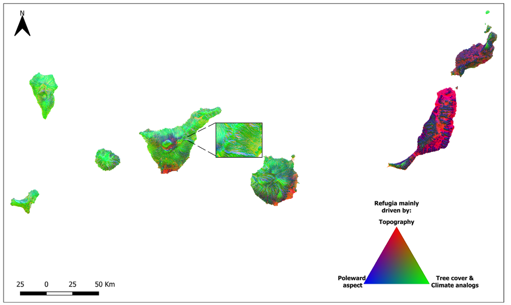
After doing all that, what I find most fascinating is how strongly these microrefugia vary across space.
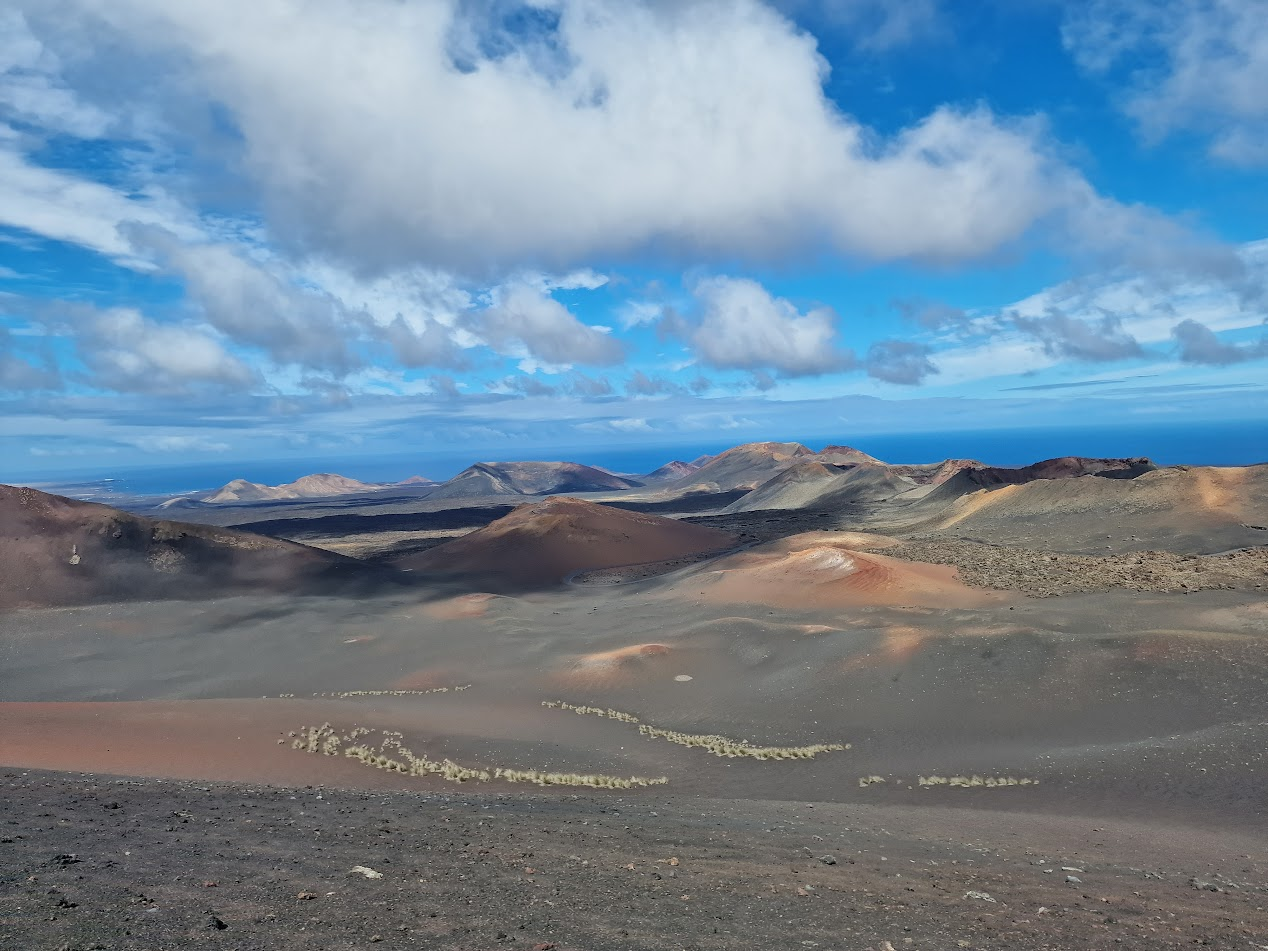
Across the Canary Islands, we see a clear east–west gradient. On the drier, older eastern islands, microrefugia are mostly driven by topography: rugged terrain creating local pockets of buffering. These islands were also more homogeneous climatically, and overall have a lower capacity to host refugia. Not surprisingly, perhaps, if you look at the desert-like landscape above.
Moving west, vegetation becomes increasingly important, adding a much stronger layer of buffering on top of topography. Same concept, very different mechanisms, and thus very different context for the organisms living there!
Once you have these maps, the next question asks itself: what can we do with them?
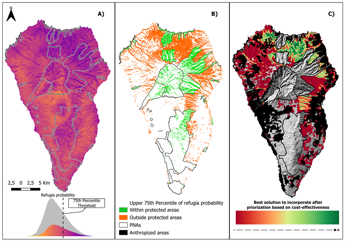
We explored this for La Palma, for example. Are these refugia already protected? Where should conservation efforts focus? The answer is… interesting, and helps open up a debate for future conservation of the region: some key refugial areas fall outside the current protected network, particularly in fragmented laurel forests and regions under strong human pressure. At the same time, there are clear opportunities to improve connectivity and strengthen the existing network – if we know where to look.
Our maps are a step forward, but of course not the final answer. Identifying refugia is only part of the story – linking them to species, management, and real-world decisions remains a major challenge.
But it’s an important step already: from mapping cold places to the multidimensionality of what defines where landscapes can actually hold on to life.
Reference: García‐Alvarado, J. J., Bello‐Rodríguez, V., Lembrechts, J. J., & González‐Mancebo, J. M. (2026). Designing a Spatial Framework to Create Refugia‐Probability Maps for Conservation Planning: Applications in the Canary Islands. Diversity and Distributions, 32(2), e70146.


")


")
")


")


")


")


")


")


