
Press release
Forest canopies cool summer temperatures with up to 10°C. An international team of scientists led by researchers from the KU Leuven in Belgium now mapped the temperature of all European forest patches to quantify the airco function of each and every one of them. You can explore how that looks for Flanders at https://www.sglobelab.com/forestairco/
Mini-weather stations on the forest floor
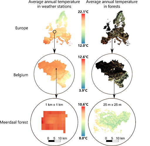
On a hot summer day, forests can feel a lot cooler than the surrounding area. Yet how much cooler a certain forest patch could be has been a lot harder to quantify for ecologists. Up till now, as an international team of researchers, led by PhD student Stef Haesen and Prof. Koenraad Van Meerbeek from the KU Leuven, Belgium, has now quantified the temperature of each and every European forest at a resolution of 25 meters, a resolution much finer than any of the 1-km resolution datasets that were currently available.
Using a unique dataset of more than 1200 mini-weather stations across all of Europe’s forests, the 52 researchers from more than 10 European countries quantified the difference in temperature between the forest understory and the existing weather station network. “This network of sensors on the forest floor is unique,” explains Stef Haesen, lead author from the study, “as it accurately captures the true temperature under the forest canopy, for forests big and small.”
Forests as thermal insulation
The data show that the maximum summer temperature in forests across Europe are on average 2°C (and up to 10 degrees) lower than outside forests. Similarly, minimum temperatures in winter can be 2°C (up to 12 degrees) higher than outside forests.
“With their foliage and branches in the canopy, trees create a thermal insulating layer above the forest floor”, explains Haesen. “For this reason, summer maximum temperatures are much lower inside forests than outside. Summer heat waves are thus strongly moderated below the tree canopy.” Forest canopies provide as such an effective air conditioning, increasingly important in a warming climate.
“Now this is the first time we have such a map at such a high resolution and over such a large spatial extent,” says Haesen. “This is a real scientific and technical breakthrough that will undoubtedly improve predictions from distribution models for forest species,” he adds. As the researchers worked at a higher resolution than ever before, their analyses also revealed never seen differences between and within forests: no two forests are the same, and differences in canopy cover, topography or tree species composition create significant variation in temperatures.
The new high-resolution forest temperature maps thus provide crucial information for researchers to analyse impacts of climate on and in forests across Europe. Haesen summarizes: “If we want to know why certain forest species grow where they are growing, we cannot use climate data from weather stations outside forests, we need the information from the location where the organisms live. These maps here are a real revolution in terms of information accuracy to know, but also to manage, the temperatures as felt by the tree saplings that constitute the forests of tomorrow.” That information becomes more important every year, as this protective shield is weakened by climate change and the increased frequency of extreme weather events (droughts and storms) that threaten the integrity of the canopy.
More information
The paper in Global Change Biology: https://onlinelibrary.wiley.com/doi/full/10.1111/gcb.15892


")


")
")


")


")


")


")


")


